Pyuthan District is a "hill" district in Lumbini Province, Nepal, about 250 kilometres (160 miles) west of Kathmandu. Pyuthan had a population of 212,484 in 2001 and 226,796 in 2011. It spans an area of 1,309 km2 (505 sq mi) and has a population of 1,309 km2 (505 sq mi). The administrative centre of the district is Pyuthan Khalanga.
Here are a few aspects of the Lumbini District.
History of Pyuthan District
Before Prithvi Narayan Shah united present-day Nepal in the second half of the eighteenth century, Pyuthan was amongst the 24 small kingdoms located in the Chaubisi Rajya alliance. Since Dang Deukhuri District in the south and Salyan District in the west had a border with the Baise Rajya confederation.
Pyuthan was a Chaubisi western outpost and most likely a barrier edge protected by fortifications, similar to Okharkot.
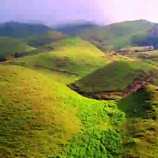
Geography of Pyuthan District
Pyuthan borders Dang Deukhuri District to the southwest along the crest of the Mahabharat Range and extends northeast through the Middle Hills to a 3,000+ meter ridge that serves as Pyuthan's border with Baglung district of Dhaulagiri Zone, as well as the main watershed between the Rapti and Gandaki River basins.
To the west, Pyuthan is bordered by the Rolpa district. Pyuthan, one of the two upper tributaries of the West Rapti River, encompasses the entire Jhimruk Khola and the lower portion of Madi Khola after it leaves Rolpa. The Madi-Jhimruk confluence is located in the Mahabharat Range, in southern Pyuthan.
Pyuthan district is centred on the Jhimruk Khola valley. During the summer monsoon, the alluvial plain is heavily cultivated with rice. Wheat is grown as a winter crop. The Madi Khola has undermined an inner canyon, making it unsuitable for irrigated cultivation.
Climate of Pyuthan District
The valleys enjoy a subtropical climate, with temperatures ranging from 40 degrees Celsius in May to single digits in the winter. Bananas and papayas are suffering from an excessive amount of winter chill. The Jhimruk Valley, at about 800 meters above sea level, is as high as it gets for mangoes, while Madi Khola is lower.
Trade harvests of citrus, Asian pear, and mulberries are grown on the surrounding hills. Maize is grown on uninundated bari fields that rise to a height of about 2,000 meters. Snow falls on neighbouring pinnacles reaching 2,400 meters now and again, although it seldom lasts more than a day or two.
Infrastructure of Pyuthan District
The Jhimruk hydropower project in Cherneta exploits the Jhimruk stream within 2 kilometres of Madi Khola while being 200 meters higher. It has a 12-megawatt capacity and powers illumination, hardware, and equipment. Because energy is deemed too expensive for cooking and heating, kindling is still widely used, with biogas usage restricted.
Transportation in Pyuthan District
Pyuthan is served by planned transportation through a side roadway off the main east-west Mahendra Highway at Bhalubang in the Deukhuri Valley's Lalmitiya VDC.
In connection with the Jhimruk hydro extension, an ancient exchange route was rebuilt for engine vehicles and is now being cleared (2010). From Tribhuvannagar (Ghorahi) in Dang Valley, a more extended, now less-travelled rock roadway navigates the Mahabharat Range to Tiram, then plunges toward Madi Khola to connect the Bhalubang street at Devisthan.
The Madi is then carried 1 km upstream to Chakchake, where a left fork leads upstream to Rolpa, while the main roadway travels to Cherneta to over a low go and enter the valley of Jhimruk Khola.
Around 10 kilometres past Chakchake, this roadway divides again, with one branch continuing north along the Jhimruk. At the same time, the main street crosses the Jhimruk and travels to Khalanga, the region's administrative centre.
Swargadwari Temple - Pyuthan District
Swargadwari, the holiest location in Pyuthan district, is thought to be the doorway to heaven since its name is made up of two crucial words: "Swarga", which means "heaven," and "Dwar" which means "door."
Swargadwari, the primary holy site of Western Nepal, is a little-visited location. Thousands of Hindu devotees from Nepal and pilgrims from India visit this temple every year.
The purpose of visiting Swargadwari is to worship the Lord, gods, and goddesses and see various sights and engage in mountainous activities such as hiking.
The temple is located on the highest point in the Pyuthan district, surrounded by Himalayan peaks such as Annapurna, Dhaulagiri, and Manaslu. The stunning Himalayan peaks seen from this vantage point are among the most exciting ways to observe natural variety.
There used to be a big mela and cultural event at Baishakh Purnima and Laxmi Puja (Tihar). If you intend to visit Swargadwari on these days, it will be possible.
How Can You Reach Swargadwari?
Swargadwari is located on the top of a hill in Nepal's Pyuthan district, and there is a direct bus route to Swargadwari from Pyuthan's Dharampani. It is preferable to plan your first trip to Bhingri, as it is the final point where you will stay in a Hotel or Lodge. Swargadwari is 13 kilometers from Bhingri. From Bhingri to Swargadwari, direct four-wheelers and Jeeps are available.